Escaping Wildfires
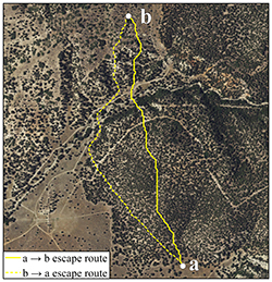 Every year, tens of thousands of wildland firefighters risk their lives to save timber,
forests and property from destruction. Geography Ph.D. candidate, Michael Campbell
and professor of geography, Philip Dennison, are mapping escape routes for wildland
fire fighters from an aerial perspective. Currently, firefighters make escape decisions
on the ground, using expert knowledge of fire behavior and assessing their ability
to traverse a landscape, but this new technology provides an extra margin of safety
for firefighters. Read more and view their published findings.
Every year, tens of thousands of wildland firefighters risk their lives to save timber,
forests and property from destruction. Geography Ph.D. candidate, Michael Campbell
and professor of geography, Philip Dennison, are mapping escape routes for wildland
fire fighters from an aerial perspective. Currently, firefighters make escape decisions
on the ground, using expert knowledge of fire behavior and assessing their ability
to traverse a landscape, but this new technology provides an extra margin of safety
for firefighters. Read more and view their published findings.
Similar coverage:
U of U study maps out escape route for wildland firefighters
Escaping wildfires
Can technology determine the best escape route for firefighters?