ESS faculty respond to Los Angeles area wildfires
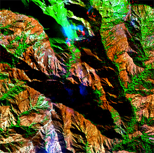
Horrific and unprecedented fires burned through the Los Angeles area communities of Pacific Palisades and Altadena last week. ESS faculty were active in explaining how the rapid evacuation in these communities broke down and collecting airborne data to map the fire and its destruction.
Hurricane force Santa Ana winds pushed fire into Pacific Palisades and Altadena, leading to evacuation notices for tens of thousands of residents. In both fires, residents abandoned their vehicles and fled on foot to escape the rapidly moving fire. Dr. Tom Cova’s research focuses on evacuation from hazards like wildfire, and he was asked to weigh in by multiple media outlets. Dr. Cova explained in an interview to KQED that many towns have limited evacuation routes, which leads to challenges when thousands of people try to evacuate at the same time, causing severe traffic congestion and gridlock. In the interview, Dr. Cova said, "It’s like being at a concert, the density of these communities, and if you leave early, you just stand up and walk out, but if you delay your departure, if you’re spending a lot of time gathering things and maybe hesitating whether or not you’re at risk, then you’ll find yourself in the midst of the main travel pull.” Articles interviewing Dr. Cova can be found on the KQED, Record Searchlight, and Inside Climate News websites.
 Dr. Philip Dennison is a member of NASA’s FireSense Implementation Team, and assisted
NASA Jet Propulsion Lab (JPL) with collecting airborne imagery over the fires. The
Eaton fire burned very close to JPL, heavily affecting the communities where many
JPL employees live. Scenes from the AVIRIS-3 instrument show the destruction in Altadena,
with fires still burning amidst the rubble. Dr. Dennison points out that the “hyperspectral”
AVIRIS-3 data that was collected will provide capabilities beyond those of typical
satellite data. “A previous AVIRIS instrument was used to map hazardous debris following
the collapse of the World Trade Center, but we don’t yet know if this capability can
be extended to homes destroyed by wildfire,” said Dr. Dennison. “We’ll be using the
data to map fire temperature, showing the areas where fire is most actively burning.”
Drs. Cova and Dennison expressed their sorrow over the loss of life and property in
the fires, and hopes that the affected communities will be able to recover. Behind
the devastation of these fires are countless individuals and families whose lives
have been changed forever. While research like Dr. Cova and Dr. Dennison’s provides
important insights, recovery will also take resilience, support, and a collective
effort to rebuild. Our hearts are with those affected as they begin the long road
to healing.
About the Blog
Discussion channel for insightful chat about our events, news, and activities.
